GUIDE TO EAST BAY CREEKS
Chapter Two
Geology & Hydrology
 When you fly over the East Bay, it is easy to see two distinct types of terrain: the corrugated ridges of the East Bay hills and the apron of flat lands that spreads from the foot of the hills to San Francisco Bay. What you might not understand at first glance is that the hills and the flat lands are closely tied to each other.
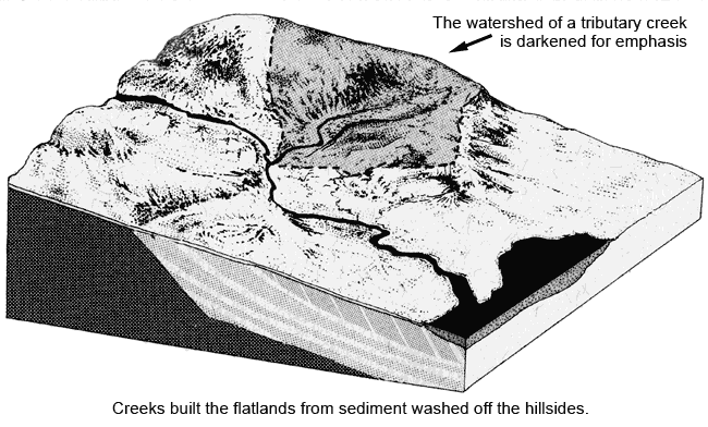
Two great forces working in tandem create both the flatlands and the hills. Continuing movement of the earth's crust uplifting the hills is counterbalanced by erosion wearing down the hills, carving valleys, and building up the flat lands. Rainwater washes soil from the surface of the hills to the creeks. Downstream, the sediment builds up layer upon layer. Streams naturally tend to shift position, especially on the flatlands, where their banks are lower and more easily overtopped. During major floods, streams will shift to new courses, leaving behind telltale lobes of sediment snaking through the landscape. Eventually, this process creates an alluvial fan, a deposit of sediment "fanning out" from where the stream first emerges from the hills, becoming wider as the land flattens out toward the Bay. The Alameda Creek fan is the largest in the East Bay, stretching from Niles to the San Mateo Bridge in the north and the Dumbarton Bridge on the south.
The action of water, however, does not erase all the evidence of crustal movement. In fact, aquatic features often indicate the location of faults. Note the jogs in Temescal, Sausal, Arroyo Viejo, and San Leandro creeks as they cross the Hay ward Fault. It runs along Highway 13, then very near the dam at Lake Chabot. Farther south Lake Elizabeth and numerous springs and seeps mark the fault's trace. The Calaveras Fault is indicated by the abrupt T in Alameda Creek in the vicinity of Sunol.
In fact, the entire flatlands area of the East Bay was built over millions of years by this kind of stream action. Alluvial fans coalesced to create an alluvial plain on top of the bedrock. If the creeks had not deposited that sediment, the hills would continue to plunge steeply all the way to the Bay and beneath it. In a few places, you can see the underlying contours of bedrock poking up, such as Albany Hill or Coyote Hills in the South Bay.
Once you recognize how powerfully the action of water has affected the shape of the East Bay, it is easier to see that knowing the watersheds is the key to understanding the physical terrain you inhabit.
In simple terms, a watershed consists of all the lands that are drained by a particular creek or river. Watersheds come in many sizes, and there are watersheds within watersheds, like Chinese boxes. If you live on a little creek like Tice Creek, you'll find that it empties into Walnut Creek. You live in the Tice Creek watershed, and also the Walnut Creek watershed, in the same way that you are a resident of both the city of Walnut Creek and the county of Contra Costa. The watershed of the East Bay includes any land that ultimately drains into the eastern shore of San Francisco Bay.

Rainwater reaches a watershed's stream in two ways, either by running off the surface or by soaking into the ground. The runoff moves downhill into gutters, storm drains, or gullies until it joins the stream. The water that soaks into the earth becomes part of the groundwater. Like surface runoff, groundwater also tends to flow downhill, through the soil and fractures in bedrock. Emerging through springs, groundwater feeds the creeks between rainstorms and ultimately reaches the Bay.
Urbanization disturbs a necessary balance between groundwater and runoff because it creates impermeable surfaces like pavement and roofs, which dramatically increase runoff. In a heavy rain, urban creeks tend to experience big, fast floods because the ground isn't absorbing enough water, and the floods come hand in hand with damaging erosion. Conversely, because the groundwater supply isn't adequately renewed, urbanization also diminishes the amount of water flowing through creeks in the summer.
--Sarah Pollock & Janet Sowers
Chapter 1 Chapter 3
Top of PageTable of ContentsGlossary |