GUIDE TO EAST BAY CREEKS
Chapter Nine
Strawberry Creek Walk
This walk follows easy, paved or groomed trails, for the most part downhill. It is not a loop. You can return to the start on a campus shuttle bus from the Hearst Mining Circle.
In 1860, the founders of the University of California chose this site on Strawberry Creek for its beauty and year-round water supply. They planted trees on the grassy plain, filled in the middle fork and began construction. In the canyon above, dairy cattle grazed and farmers cleared the land. Runoff and pollution increased. By 1895, the creek water was described as "sewer-begrimed" — a condition that persisted for the next 90 years. Since the mid-1980s, the campus community has cleaned up the creek. Today, Strawberry Creek is an internationally recognized model of urban creek restoration.
Entering the U.C. Botanical Garden, keep to the main path on the left all the way to the rose garden. From this knoll, you can see down Strawberry Canyon, across Berkeley, to the Marina: Strawberry Creek's route to the Bay. Downstream of the campus early developers channeled the creek into culverts, and by the 1930s it was completely underground.
Follow the same path as it loops back around to the Asian section. Here Strawberry Creek enters the garden, highly sculpted and channelized, with paths, steps, and a Japanese pool. The creek bed is wholly artificial, sculpted out of large rocks that came from Japan for the 1939 World's Fair. Although two native minnows, roach and blackfish, have been introduced into this pond, it is currently dominated by mosquitofish, an alien species.
Continue downstream on the creekside path built on the flood plain. The rock works were WPA projects of the 1930s. The path crosses the creek at the dawn redwoods, a rare and ancient deciduous species from China. At the main path, look upstream from the bridge. From left to right you can see the oldest (dawn), tallest (coast), and biggest (giant) species of redwoods. The creekbed is concrete lined above the bridge and earthen below, where for the native plant area, a more natural appearance was desired.
At the north end of the bridge, take the path downstream to the Weeden Trail, a sequence of walks, steps, and decks. The deck beneath the waterfall is a good place to see hummingbirds. Further on stop to read the interpretive signs.
Continue west, then up to the right through the "scrub and chaparral" area, with clumps of bunch grass and a stunning stand of coast live oaks, both native to the Bay Area hills. Walk back through the picnic area, down a small path to another creek branch and continue upstream. There is a good selection of Streamside plants of the coastal coniferous forests. Several plants are native to Strawberry Canyon.
Leaving the Botanical Garden, walk down Centennial Drive and on to the fire trail into the Ecological Study Area. You'll be walking upstream, past stone bridges where the creek branches emerge from the garden into a canyon filled with mossy bay trees. Native oak and chaparral cover the hillside, along with Monterey pine and eucalyptus introduced in the 1930s and 1940s. This is the most natural section of the creek, although weeds, check dams, and fire-suppression activities have altered the scene.
Return to the fire trail entrance. Here an earthen dam, used as a parking area by hikers, channels Strawberry Creek into the "Big Inch," one of two culverts that run over 4,000 ft. before emerging on the main campus. "Little Inch," the original culvert to the campus, begins further downstream. Leave the road at the driveway behind the recreation area and walk between the fence and the hillside. Imagine the bays and oaks of the cool canyon that were replaced by these pools and playing fields; think of the creek, buried below you.
You'll arrive at Memorial Stadium, built across the mouth of Strawberry Canyon in 1923, obliterating a waterfall. You are standing on the Hayward Fault. Over the years, movement along the fault separated the culvert and the sewer lines, causing serious pollution of the creek — especially during half time at football games — until the sewer was repaired in 1988.
Walk to your right along the road above the stadium, down to Galey Road. Cross the street and enter the campus. The creek emerges from the "Little Inch" at the north end of the parking lot, behind the Women's Faculty Club. Follow the creek downstream to where the "Big Inch" discharges into the creek.
The creek appears natural, but look again — culverts jut from the banks, and bank stabilization techniques reflect the water and erosion control policies of different eras. Ivy and periwinkle cover the banks. Not even the redwoods are native to this spot.
Follow the creek through Faculty Glade, once settled by Native Americans. Salmon were last seen in this part of the creek around 1930. Today, reintroduced fish and insects seem to be responding well to the creek committee's efforts to clean up the creek, although downstream culverts will continue to prevent steelhead migration. Minnows, might be seen west of the glade in the pool above the crib wall.
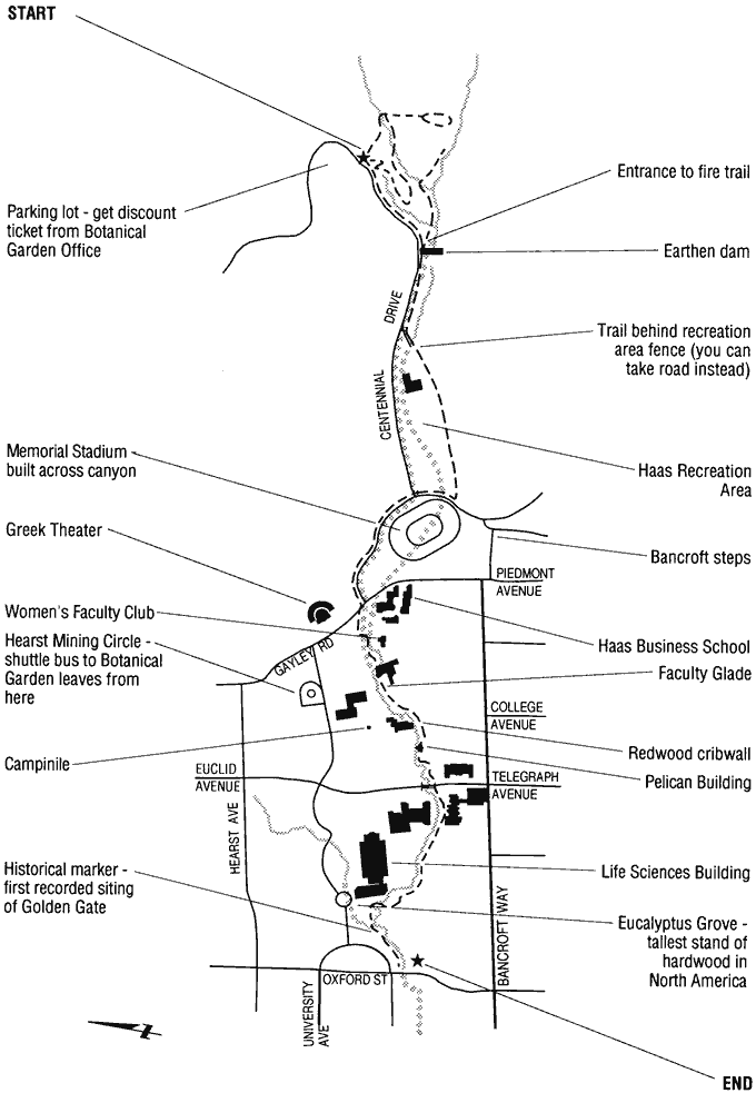
Take the path to the south of Stephens Hall and stop on the large concrete bridge. Look upstream to see an innovative solution to severe erosion of the south bank of the creek: a crib wall. To achieve this biotechnical bank-stabilization technique, redwood logs were inserted into the creek bank, other logs laid log-cabin style across them and the gaps planted with native vegetation. When the logs rot away in 75 to 100 years, the plants should be able to hold the bank against erosion.
Continue further on, and walk behind the Pelican building (Anthony Hall). Here an example of erosion control remains from 1907, when the entire creekbed was lined with concrete and stone. This hardbed became severely undercut by erosion. Check dams have slowed the water flow, allowing the undercut to silt in gradually.
Follow the main path to the creekside glade east of Sather Gate. The natural-appearing meander along this section of the creek was created recently when some water was freed from a culvert and the area landscaped with native vegetation and places to sit. The stick gauge in the creekbed is to monitor water flow, one of many creek-oriented activities included in U.C. courses.
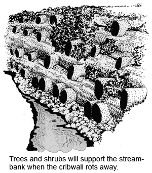
Continue west on the path and banks of Strawberry Creek. They have been groomed in a variety of ways, in a variety of eras, offering myriad oases of calm amidst the bustle of academic life. The meander around the southwest corner of the Life Sciences Building is the most unaltered streambed on the main campus. The pool and undercut bank provide a good habitat for the reintroduced stickleback. The North and South Forks meet beyond the Eucalyptus Grove. Before the creek disappears into the city storm drains, there are large wooden and metal barriers designed to keep debris from entering the culvert. Here you can say goodbye to Strawberry Creek.
-- Shelby HallChapter 8 Chapter 10 |
Top of PageTable of ContentsGlossary |