GUIDE TO EAST BAY CREEKS
Chapter Thirteen
Alameda Creek Tour
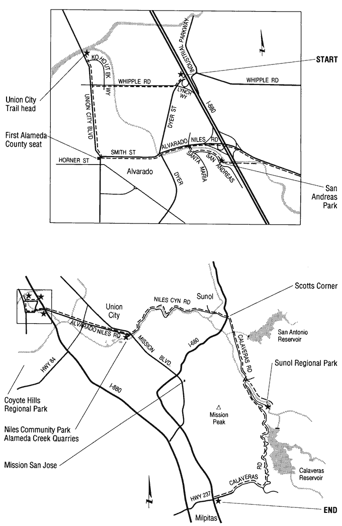
Total distance from Whipple Road and I-880 to Milpitas is 40 miles. Walks are easy, on smooth terrain, but wear hiking shoes if you plan to clamber down streambanks.
Alameda, the longest and largest East Bay creek, drains 700 square miles behind the East Bay Hills. At Sunol, it pours west through Niles Canyon, depositing rock eroded along its course onto the flatlands, creating a 400-foot-deep alluvial gravel deposit called the Niles Cone.
Eighteenth-century Spanish explorers beheld Alameda Creek cutting its main channel through a broad flood plain of sloughs and fertile land, replete with vegetation and wildlife supporting the native people living along its banks. Mission San Jose was established nearby in 1797.
Today the lower creek is a highly engineered flood-control channel, mostly empty of water. It cuts a smooth 12-mile line through the suburban sprawl of Fremont and Union City to the Bay. Yet vestiges of history remain in place names, markers, some buildings, and, though radically altered, in the creek itself.
Drive south on I-880 from Oakland to Whipple Avenue. Drive west to Union City Boulevard and turn right. Pull over and park at the bridge just past Kohoutek Way.
This is currently the west end of Union City Trail, which follows the historic route of the creek from here to the flood-control channel. Recently developed, Union City has incorporated its creeks into the townscape. What remains of Alameda Creek runs through an open channel and is fully accessible to the public from creekside trails. Where main roads cross the trail, bridge rails have a distinctive wood-beam design; wooden entry markers are made in local schools' shop classes. In a car-culture community, the trail is a practical transportation route for pedestrians and bicyclists where one can enjoy the shade and sounds, the vegetation, and the animal life of a riparian corridor without trespassing on private land.
To the east, Alameda Creek has been channeled between levees. The wide creekbed flows through new industrial parks and developments. The banks offer opportunities for community clean-up and planting activities. If you climb down the muddy bank you can see barnacles and pickleweed, signs of salt-water presence this far upstream. A patient observer might see a carp or two. Although the creek bottom appears shabby, it hosts a great variety of bird life, including dramatic great blue herons, great and snowy egrets, and white pelicans. (These and a multitude of other birds are listed in "Birds of Alameda Creek Trails and Quarries," available at Regional Parks visitor centers.)
Look across Union City Boulevard to see (as of 1993) a remnant of farmland. When Union City was incorporated in 1959, farms extended all the way to the foothills. There are plans to extend the trail to the west and south to the "Big Elbow," site of the first landing on Alameda Creek.
Back in your car, make a U-turn on Union City Boulevard. About a mile south is the heart of the historic area where three small towns vied for prominence in the 1850s and had a brief moment of fame in 1853 as the seat of newly formed Alameda County. The first Union City was laid out along Horner Road towards the first wharves and warehouses on the creek. To the east, Mr. Smith founded the settlement called New Haven, after his hometown. Just south, land speculators created Alvarado.
Drive east along Smith Street where signs reflect today's multicultural population: the Arabic Translation Service, the Barcelona-Madrid Restaurant, the Korean Catholic Church, and the Wiki-Wiki Pit Stop.
Continue east to the intersection of Dyer Road (you are now on Alvarado-Niles Road). On the northwest corner, the Sugar Mill Landing Park sign marks another entrance to the Union City Trail. It commemorates the first sugar mill in the United States. Built by Mr. Dyer in 1870, it continued operation at this site until 1969.
Turn right at the next street, Santa Maria. Take the first left, San Andreas, to San Andreas Park, tucked between a freeway on ramp and a tract development. Here, local children riding dirt bikes have sculpted a fantastic racecourse into the creek banks. But, along the creek, you get the feel of the once-expansive riparian woodland that gave the creek its name.
Follow the trail to your right to where it passes under the freeway, a place of unusual feelings and sounds. A small, straight ditch runs down one creek bank and up the other. Can you figure out why? Children playing here find frogs, snakes, and other critters — egrets preen. Continue walking past the Holiday Inn to the Almaden Street crossing where a Bicentennial Time Capsule ("to be opened July 4, 2076") is built into the bridge. Formerly the major outlet to the Bay, this section of creek has been severely dewatered by the flood-control channel. Regarding today's tiny trickle of water, contemplate the transformation of the East Bay's largest creek into a storm drain.
Return to your car and take Alvarado-Niles Road, crossing I-880 to the east. It's hard, from the road, to imagine that the creek exists just a few feet away. Forays off Alvarado-Niles to McCann Park, at the end of Hop Ranch Road, or the Civic Center, off Royal Ann, yield spots where the creek has been incorporated into city parks.
Continue east on the Alvarado-Niles Road to the historic community of Niles, which began growing here in the 1850s. The old-fashioned downtown storefronts house antique shops and boutiques, and the back streets are lined with 19th-century cottages. For a brief time during World War I, movies were made in Niles, and stars like Charlie Chaplin and Gloria Swanson stayed here.
Turn right on H Street. Park at the corner of 3rd and H Streets at Niles Community Park, and stroll through the park. The concrete paths may seem cold and sanitary in what was a wild, overgrown area, but they provide the access for wheeled vehicles lacking in many parks. The park is built around the site of one of the first quarries where the early settler, Mr. Shinn, had an exotic plant nursery. Then the railroads and finally 20th-century industry left huge holes, scarring the creekside landscape. As water seeping into the holes was pumped out and large farms pumped well water for irrigation, the water table fell so low that salt water crept into the South Bay's underground water supply.
In order to reverse this damage, commercial quarrying ceased, and in the early 1970s, two huge, inflatable rubber dams were built across the flood control channel near Niles. Alameda Creek waters were pumped from behind the dams into the quarry ponds. Now, fresh water percolates back into the aquifers, keeping the salt water at bay. Walk through the park to the flood control channel and west along the trail for a great view of the rubber dams and the quarry ponds.
Return to Niles Boulevard and proceed east. Turn left under the railroad track. Cross Mission Boulevard onto Niles Canyon Road. Historically, the creek was the border between Mission San Jose and the Rancho Arroyo de la Alameda, granted to Jose de Jesus Vallejo. Vallejo Mill Historic Park is located on the intersection's northeast side. Niles Canyon was the source of lumber and firewood for the first settlers at the mission.
Follow Niles Canyon Road along the creek through the canyon. The rail bridges and tunnels date from the early 20th century, and the two-lane road follows the contour of the land, giving an "early days" feel belied by the high-speed traffic and the nests of satellite dishes on the hills. The first transcontinental railway ran through Niles Canyon, and there are two major rail lines through the canyon today. The Pacific Locomotive Association runs excursion trains through here, departing from the Sunol station on the first and third Sunday of each month.
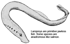
The Alameda Creek watershed stretches from Mt. Diablo in the north and Altamont Pass to the east, south beyond the slopes of Mt. Hamilton, east of San Jose. These far-flung waters join in this area for the run through Niles Canyon. Gravel deposits from these converging streams lie beneath the valley floors and are used as a natural water-storage facility by the San Francisco Water District. At Scotts Corner, turn south on Calaveras Road, following the course of Alameda Creek toward its headwaters.
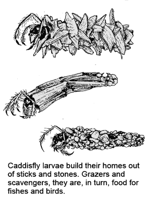
Drive a few miles south to the Sunol Regional Wilderness. Pick up a park map at the park entrance, and check the Interpretive Office (open weekdays, 9 - 5) bulletin board for events. Access to the creek is easy; it is full of insects, frogs, and fish. To get to Little Yosemite, a scenic gorge on the Alameda Creek, drive to the end of the paved road and park. Walk upstream on the fire trail (ok for baby strollers, possibly wheelchairs) for about a half-hour (1.6 miles). Leaving time to explore side paths, climb down into the gorge, and relax and enjoy. This walk takes about 2 hours.
For a scenic finish to the tour, continue south on Calaveras Road. This narrow road overlooks Calaveras Reservoir, created by damming a tributary of Alameda Creek. Driving through this undeveloped land, with its spectacular views of the mountainous Alameda Creek watershed to the south, makes you feel as though you could be in the 1920s. After 10 miles, Calaveras Road turns west, where you can take I-680 or I-880, making a quick return to present day "civilization."
-- Shelby Hall
Chapter 12 |
Top of PageTable of ContentsGlossary |