Guide to San Francisco Bay Area CreeksFremont Flood, 1955An event that stimulated a major flood-control project.
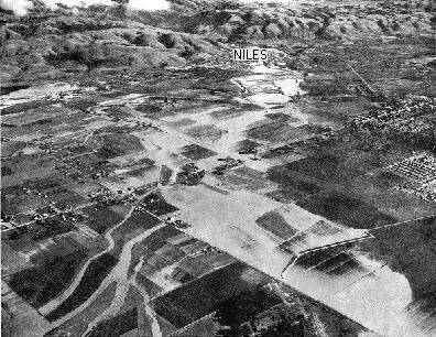
Flood waters inundate farms, roads, and homes in this aerial photograph taken December 24, the day after the flood crested. The intersection of Fremont Boulevard and Decoto Road is in the middle left, and Patterson Ranch is in the front center of the photo. In the days before Christmas in 1955, heavy rain filled Alameda Creek to overflowing and the floodwaters spilled out over the flatlands of Fremont and Union City. Historical and geological records show that the creek has probably flooded like this every 50 to 100 years for many thousands of years. Alameda Creek is the largest stream in the county, draining all of Livermore Valley through Niles Canyon. Before urban development, each flood laid down another layer of sediment on the flatlands of the Fremont area. Indeed, the flatlands were built by the creek. The soil here consists of layer upon layer of sand, silt, clay, and gravel deposited by the floodwaters of Alameda Creek. These deposits form an alluvial fan, a gently sloping fan-shaped deposit, radiating from the outlet of Alameda Creek near Niles. With new homes and businesses locating on the Alameda Creek fan, it was no longer desireable to allow nature to take its course. Prompted by the flood of 1955 and a similar flood in 1958, the residents voted to create the Alameda County Flood Control District and a flood control channel was built to carry floodwaters out to the bay. This channel, about 200 feet wide, 10 miles long, and bordered by 20-foot high levees, holds much more water than the original creek bed. As of the spring of 1997, it has not yet been overtopped by flooding. The natural cycle of flooding and alluvial fan construction has been suspended for now. Maps of the extent of the 1955 flood waters, along with flood height records back to 1919, are published on U.S. Geological Survey Hydrologic Atlas HA-54 by L.E. Young.
|