Guide to San Francisco Bay Area Creeks
Santa Clara Valley
Land Subsidence
Much of northern Santa Clara Valley sank at least eight feet
Problem of Subsidence
Since the day in 1854 when the first well went in, the Santa Clara Valley has subsided up to 13 feet as groundwater was pumped for agricultural and urban use. Over-pumping of groundwater during the early twentieth century lowered the pressure in the groundwater aquifer to the point that deep layers of alluvial sediment settled, causing the land surface to subside, that is sink relative to the surrounding terrain and sea level. Only through extensive groundwater recharge has land subsidence been curtailed.
Groundwater Abundance
Flanked by mountains on either side, the Santa Clara basin lies in a trough that is underlain by many hundreds of feet of alluvium, layers of sand, gravel, silt, and clay. Winter rains that fall on the basin either flow to San Francisco Bay via surface creeks and rivers, or soak into the porous alluvium joining the groundwater system. In the second half of the nineteenth century, most wells tapping this groundwater system north of San Jose were artesian -- water under pressure beneath the surface rose up in wells and gushed out on the surface.
In the early twentieth centuries, however, groundwater levels dropped dramatically as irrigation-intensive fruit and vegetable cultivation expanded and wells extracted groundwater faster than it could be replenished. In just the nine years from 1919 to 1928, the water table dropped over 60 feet in the Mountain View-Milpitas area. The drawdown in water levels led to an increasing area and amount of land subsidence, well failures, and a greater hazard of flooding by rivers or the bay.
Restoration Measures
Beginning in the 1930s, local, state, and federal water agencies constructed dams, canals, and groundwater recharge ponds to replenish the groundwater. Later, aqueducts were built to bring additional water into the valley from the Sacramento-San Joaquin delta. The imported water helps by reducing demand for groundwater as well as by supplying more water for recharge. The current recharge program includes 10 reservoirs, 393 acres of percolation ponds, and 159 miles of conduits and pipelines.
By 1969, groundwater levels recovered and ground subsidence largely ceased. Land subsidence cannot be reversed, however. The subsided lands along the mouths of major rivers and the southern margin of San Francisco Bay remain susceptible to flooding by the rivers and tides. The cost for bay levee construction and maintenance represents about three-fourths of the calculated direct costs of land subsidence, or about $300,000,000 in 1998 dollars.
Nineteenth Century San Jose
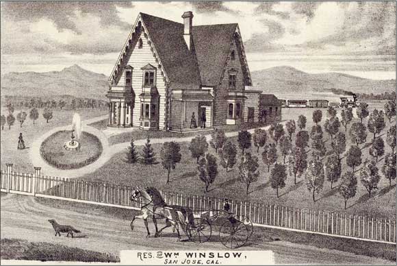 This lithograph from the 1876 Historical Atlas of Santa Clara County shows a fountain gracing the front yard of the Winslow home in San Jose. Fountains such as these were common in the late nineteenth and early twentieth centuries, and flowed naturally from artesian wells. Family fruit orchards, such as the one depicted here, inspired the region�s nickname, the Valley of Heart�s Delight. Image courtesy of the David Rumsey map collection.
Subsidence Contours
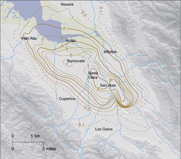 The contour lines on this map of the Santa Clara basin mark equal amounts of land subsidence for the period 1933 to 19679, measured in feet. Additional subsidence occurred before 1934, so the contours only show a portion of the total change. Contours from Poland and Ireland, USGS Professional Paper 497-F (1988)
Depth to Groundwater and Land Subsidence
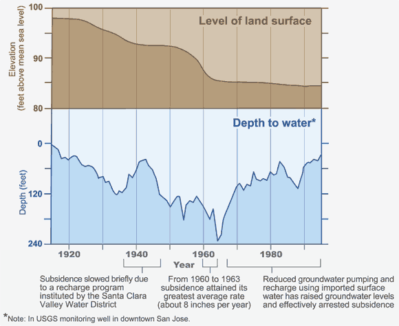 As water was pumped from the ground, the land surface above slowly sank. The blue graph shows changes in groundwater levels in a downtown San Jose monitoring well from 1915 to 1999. The brown line above shows corresponding changes in land elevation, at an exaggerated vertical scale. Modified from Ingebritsen and Jones, USGS Circular 1182 (1999).
-- Stephen C. Thompson & Janet M. Sowers
See accompanying page on Santa Clara Valley Groundwater System.
|