Guide to San Francisco Bay Area Creeks
The Guadalupe River
Taming an Urban Stream
History of Flooding in San Jose
The Guadalupe River has always been part of the identity of the city of San Jose. The present downtown area of San Jose was originally laid out in 1847 along the banks of the stream named Rio de Nuestra Se�ora de Guadalupe by Juan Bautista de Anza. Early residents relied upon the river for irrigation water, fishing, power for mills, and a transportation corridor. Unfortunately, the river was also the source of damaging floods. The original Pueblo de San Jose, established by Mexico in 1777 about one and a quarter miles downstream of modern San Jose, was abandoned and relocated after winter floodwaters repeatedly inundated that low lying area. Yet even on higher ground, within a year after the pueblo was moved, the flood of 1849 again sent residents scrambling. The Mission Santa Clara de As�s - also established in 1777 along the northern bank of the river - was flooded in 1779 and moved twice by 1784, each time to higher ground.
Flooding is a Natural Event, But...
For most any river, flooding is a common, natural, and often beneficial occurrence. Indeed, the fresh layers of silt that once spread out on the valley floor with each flood of the Guadalupe River and Coyote Creek gradually built up the deep, fertile soils that led to the success of the "Valley of Heart�s Delight" as an agricultural center. Writers of 1876 describe the soils as "yielding the richest harvest on the slightest provocation."
Flooding, however, is not compatible with the modern urban landscape. The present city of San Jose is still subject to floods from the Guadalupe River. With a large watershed draining an area of 170 square miles and collecting the flow of four major Santa Cruz Mountains streams, intense winter storms can cause the river to swell beyond its banks and spill into city streets. Such floods cause extensive damage to public and private property, covering roads and highways, and disrupting rail transportation routes.
How High?
How Often?
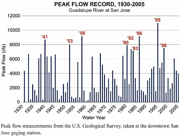
Since 1930, the U. S. Geological Survey has been recording river heights in downtown San Jose. The downtown San Jose gaging station - for many years located near the West St. John Street Bridge, and then relocated to Highway 101 in 2003 - continues to monitor water levels. The peak flow records (see graph) show the highest water level recorded for each water year, October through September.
Some years peak flow is low, some years peak flow is high, as the pattern of short and long bars on the graph shows. Flows greater than 7,000 cubic feet per second (cfs), or 12 feet high on the gage, were historically large enough to overtop the banks in the downtown area. Such floods have happened nine times since 1930. In 1995, the largest flood of record, measured at 11,000 cfs or a gage height of 17 feet, turned streets into rivers, flooding approximately 300 homes and businesses and blocking Highway 87 (see photo). Now that the downtown and lower Guadalupe flood-protection projects are completed, a discharge of 17,000 cfs would be required to overtop the banks.
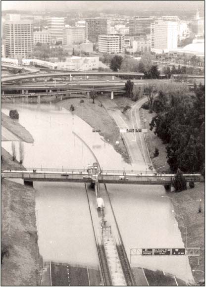
The flood of 1995 was the greatest flood ever recorded in San Jose. Highway 87 flooded from the West Virginia Street overpass to Interstate 280. Downtown San Jose is seen in the background. Photo by: Santa Clara Valley Water District.
Reducing Flood Risk
Millions of dollars have been spent and millions more will be spent before flood risk can be reduced to acceptable levels along the entire Guadalupe River. Indeed, as the valley has urbanized, the magnitude of flooding from equivalent rainstorms has increased. More impermeable surfaces - pavement and rooftops - mean that, rather than soaking into the ground, rain quickly runs into the streams. The streams and the older engineered channels are often not large enough to contain modern flows.
Insets on the map of the Guadalupe River Watershed include examples of modern flood-protection strategies. These projects are designed to contain the 100-year event, a flood with a one percent chance of happening any given year. Older projects typically focused on flood containment. Modern projects blend flood protection with the preservation and enhancement of natural habitat and creation of public open space.
|