GUIDE TO EAST BAY CREEKS
Chapter Four
Cultural History
 For most of the East Bay's human history, life revolved around local creeks as sources of water, food, and many other needs. Hunting, fishing, cooking, and drinking all depended upon a healthy watershed. But in the 20th century, Bay Area cities began importing water from the High Sierra, and the local creeks came to be seen as more of a nuisance than a necessity. People lost their intuitive connection to the watersheds they inhabit. Only recently has a deliberate effort begun to reawaken understandings once so obvious they needed no articulation.
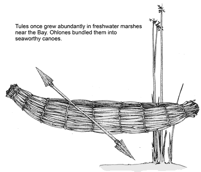
The original East Bay residents, the Ohlone Indians, situated their villages near the mouths of creeks. In part, this was because of the abundant shellfish beds and other food sources located there. You can still find traces of that past in the piles of shells the Ohlones left near the shore. Shell Mound Avenue in Emeryville bears the name of a shell mound that existed at the mouth of Temescal Creek well into the 20th century.
Further upstream, the creeks were good places to wait for game, and the Ohlones fished for steelhead and salmon. They sometimes dammed creeks to irrigate small pieces of land. During spring and summer, the Ohlones gathered acorns in the hills and used creek water for leaching and cooking acorn mush.
 When creeks quit flowing during the dry season, the Ohlones dug wells along their banks. They also built sweatlodges along creeks, working up a sweat in the heated huts and then plunging into the water to cool off. One such lodge gave Temescal Creek its name, temescal being derived from an Aztec word for sweatlodge.
When the Spanish built their missions in the late 1700s, they brought cattle and other livestock, which made the biggest single impact on the landscape before urbanization. Livestock caused enormous damage to creeks because cattle gather there for shade and water. Grazing denuded the banks, then trampling destroyed the streambed contour, eliminating shelter for fish. On the hillsides, grazing brought the decline of native bunchgrasses and led to erosion.
The damage grew worse after Mexico's independence. Lands were granted to the Peralta and Vallejo families, who worked their ranchos for profit and greatly increased herd sizes.
Another landmark transformation of the East Bay followed the discovery of gold in 1848, shortly after the United States took California from Mexico. In one year, San Francisco boomed from 500 residents to 25,000.
To build the new city, a logging frenzy followed in the San Antonio Forest, which once marked the headwaters of Redwood and San Leandro creeks. The trees, so tall they served as navigational landmarks for ships entering the Golden Gate, were reportedly 12 to 20 feet in diameter. The use of creeks as skid roads and the denuding of the hillsides resulted in erosion and flooding.
Soon afterward, in 1852, the City of Oakland incorporated. Simultaneously, an informal community established itself at the mouth of Strawberry Creek in what became Berkeley. Called Ocean View, the community had, as an early economic enterprise, a gristmill that used water from the creek. Hayward and San Leandro sprang up alongside creeks in the 1860s, using local water from dams and wells for homes and small industry.
East Bay urbanization leaped forward following Oakland's establishment as the transcontinental railroad's terminus in 1869. Sensing future demand, Anthony Chabot started the East Bay's first centralized water system in the late 1860s, with Lake Temescal as the first reservoir. Chabot later used hydraulic monitors (water cannons), which he developed for gold mining, to carve out a canyon in San Leandro Creek, creating the reservoir named Lake Chabot.
With urban development came the gradual destruction of creeks and marshes. Dramatic examples are the tailings of Chabot's hydraulic excavation and the enclosure of an arm of the Oakland Estuary to create Lake Merritt. About the same time, the young University of California dammed Strawberry Creek for a small water system, and downstream in Ocean View the water level in wells dropped. Thus began the first big battle between hill and flatland residents over water rights.
After the turn of the century, the Bay Area took the final leap away from dependence on its own watershed. San Francisco built the Hetch Hetchey system in the Sierra Nevada for water, and the urban East Bay followed suit with Pardee Reservoir. The largest cities joined forces in 1923 to form the East Bay Municipal Utility District (EBMUD). For the first time in the human history of the East Bay, local creeks seemed irrelevant to survival.
Early plans for East Bay development called for preserving the East Bay's creeks as ribbons of riparian parkland. These would have been assets to the neighborhoods and would have allowed the creeks room to shift their courses without causing property damage. Unfortunately, the necessary land was never acquired. Urbanization during the 1920s and 1930s spread right up to the creek banks, absorbing the greenbelts.
By this point, people had lost their connection to creeks as necessary for survival; they came to regard them more as threats or nuisances to be controlled. With urban encroachment, the streams encountered a number of problems. Dumping of automobiles, shopping carts, yard wastes, et cetera blocked the streams, reducing their capacity to carry runoff. Pavement and roofs increased runoff, which increased flooding, which caused creeks to change course, which damaged buildings built too near the creeks. Early sewers fed into the creeks. Even after sewers were separated from storm drains, urban runoff brought street grime and toxics into the creeks. So many creeks became health hazards.
To address these problems, East Bay cities and Alameda County formed the Alameda County Flood Control District. Together, they built various public works projects, including storm drains, flood control channels, concrete walls, and dams. These structures efficiently carried runoff from the hills to the Bay, minimizing property damage, and dealt with the dumping and pollution problems by isolating people from the creeks.
Even as the creeks were first being buried, early groups formed to recognize their value and fight for their preservation. Annie Maybeck, wife of architect Bernard Maybeck, helped found the Hillside Club in Berkeley, which
urged road builders to follow the contours of the landscape and keep at least some creeks open. But most of the creeks of Oakland and Berkeley continued to be converted into flood control structures, without regard for aesthetic
or ecological values. This disregard has spawned a rapidly growing urban-creeks restoration movement, which advocates recognizing and valuing our connection to the watershed we inhabit, and incorporating wildland resource
values into flood-control and creek-restoration projects.
--Sarah Pollock & Charles Wollenberg
Chapter 3 Chapter 5
Top of PageTable of ContentsGlossary |