Guide to San Francisco Bay Area Creeks
Coyote Creek Watershed
The Coyote Creek watershed is the largest in the Santa Clara basin, comprising 350 square miles of land that drains into Coyote Creek and its tributaries.
Introduction
This diverse watershed extends from the flanks of the Diablo Range at elevations of over 4,000 feet to San Francisco Bay, encompassing oak forest, grassland, and urban areas of Morgan Hill, eastern San Jose, and Milpitas. The watershed is home to over one-half million people and provides riparian and aquatic habitat for a wide variety of plants and animals, some of which are threatened or endangered. For the population living, working, and visiting in the watershed, the numerous creeks and creek side habitats are a prized asset, providing clean drinking water, recreation, and wildlife habitat. At the same time, their associated flooding, erosion, and pollution present liabilities.
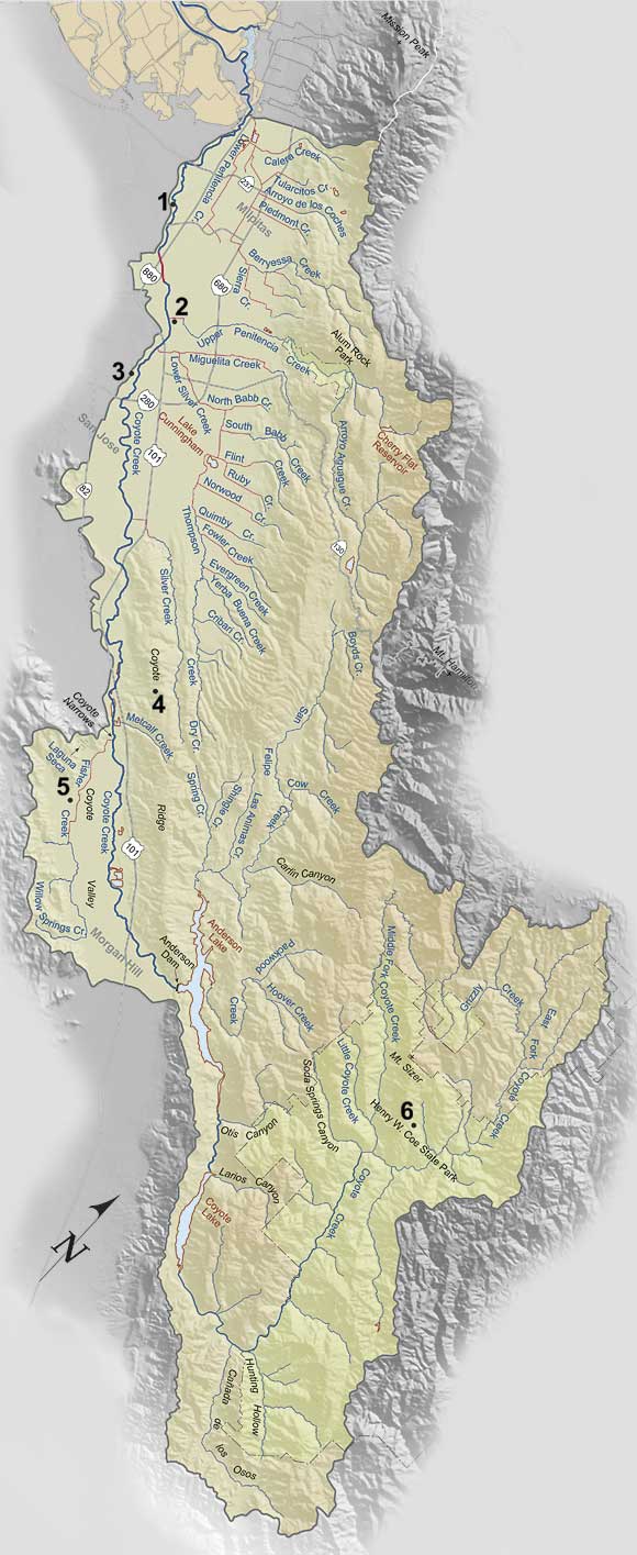 The adjacent map highlights the Coyote Creek watershed that drains to the baylands and marshes of San Francisco Bay, directly below the confluence of Lower Penitencia Creek and Coyote Creek. North and west of this point, Coyote Creek is a tidal slough that extends to its confluence with Mud Slough. The upland area that drains to the confluence of Coyote Creek and Mud Slough also includes the map area outlined in white. This additional area includes land drained by Laguna Creek, Mission Creek, Scott Creek, and other smaller creeks and engineered ditches.
Human Impacts on the Watershed
The increase in the human population since the arrival of the Spanish explorers in 1769 has both stretched our use of the land�s natural resources and amplified our vulnerability to the natural processes that occur within the watershed. As a result, the Coyote Creek watershed is now highly altered. Many of the alterations drastically changed the natural function of the watershed system. In its natural state, water and sediment from the uplands of the Diablo Range discharged to the valley lowlands during winter storms, depositing large amounts of sediment on alluvial fans within the piedmont and across the Coyote Creek floodplain. Water that did not flow via Coyote Creek to San Francisco Bay sank into the porous alluvial soil and replenished the groundwater reservoir beneath Santa Clara Valley. Willow groves, freshwater marshes, and broad floodplains provided abundant riparian and aquatic habitat that served a flourishing ecosystem.
Today, the altered watershed functions differently. Coyote and Anderson dams, built to impound water for irrigation, groundwater recharge, and municipal water supply, also trap sediment
from the upper watershed and regulate flow of Coyote Creek, preventing much of the natural alluvial-fan and floodplain deposition. Construction of levees and engineered channels, which
protect neighborhoods from damaging floods, also restricts the natural migration of stream channels across alluvial fans and floodplains. Over-pumping of groundwater - first for irrigation,
later for drinking water and industry - necessitated the importation of water from outside the Santa Clara basin and construction of percolation facilities to maintain groundwater
levels and prevent subsidence of the valley floor. Storm water that formerly infiltrated the porous alluvial soil to replenish groundwater reservoir now mostly runs off impermeable
rooftops and streets into underground culverts or engineered, concrete-lined channels leading directly to Coyote Creek. Natural willow groves, marshes, and riparian corridors are largely
gone - drained, or altered to accommodate expansion of the population.
Stream Restoration, Rehabilitation, and Improvement
Stewardship projects that include habitat or stream restoration as a goal may not attempt to recreate past conditions exactly. Given the extensive human-caused changes in the watershed, full restoration of the stream system can be unachievable at a project site with competing needs and limited funds. Allowing a stream to range freely, depositing sediment over its entire floodplain and alluvial fan is seldom compatible with an urban environment. Typically, restoration in an urban environment consists of rehabilitating or improving selected characteristics of the former environment, such as riparian habitat or water quality.
A Healthy and Safe Environment for All
Stewardship of any natural resource necessarily reflects society�s values and can often be a delicate balancing act among a variety of interests and goals. Since the early 1990s, stakeholder forums in the Santa Clara Basin have convened to address improvements in bay water quality, protection and enhancement of creeks and wetlands, and more recently watershed stewardship. Participants include local governments, resources and regulatory agencies, private property owners, and representatives from the business, agricultural, environmental, and civic communities. Participants establish goals and plans to resolve policy and permit disputes.
Larger-scale examples include the 1996 Santa Clara Basin Watershed Management Initiative (WMI), and the 2002 Santa Clara County Water Resources Protection Collaborative. In 2000, the enabling legislation of the Santa Clara Valley Water District was amended to recognize stewardship as a purpose of the agency, and over two-thirds of Santa Clara County voters approved a special tax measure sponsored by the District to fund �Clean, Safe Creeks and Natural Flood Protection� for fifteen years. The District, with advice from WMI stakeholders, produced a stream stewardship plan for the Coyote Creek watershed in 2002. The plan includes over sixty projects to benefit flood protection, habitat enhancement, parks, and trails. Similar stream stewardship plans were produced in 2005 for the District�s Guadalupe, West Valley, and Lower Peninsula watershed management areas.
All of these processes require a significant commitment of time and money, and active participation from local agencies and community volunteers, but they can result in substantial improvement in planning for stewardship of local resources. This map highlights examples of current projects with multiple benefits in the Coyote Creek watershed.
-- Stephen C. Thompson & Janet M. Sowers
See accompanying page on Santa Clara Valley Land Subsidence.
|