GUIDE TO EAST BAY CREEKS
Chapter Ten
Sausal Creek Walk
This walk begins easily and becomes steeper and more rugged. Hiking shoes are recommended. The approximately two-mile walk described is not a loop. You can return along the trail, descend along city streets, or take public transportation, which serves both ends of the walk.
Fruitvale Avenue runs up the floodplain of Sausal Creek, the area regularly inundated when the creek rose over its banks. The remarkably fertile soil produced by regular flooding (think of ancient Egypt) gave rise to lush vegetation -- oaks, willows, berries, flowers -- and was home to a great variety of birds and animals. Sausal, willow in Spanish, comes from the thick willow groves that grew along the banks.
In the mid-19th century, Fruitvale Avenue led into the rich timber area that supplied lumber for the fast-growing East Bay communities. Known as San Antonio Forest, the huge trees -- some 32 feet in diameter -- extended from upper Dimond Canyon over the hill through Joaquin Miller and Redwood Regional Parks and on to Moraga. Oakland's first sawmill was built along the Palo Seco branch of the Creek; oxen pulled redwood logs on skids along Fruitvale Avenue
Take Fruitvale east from I-580. At MacArthur Boulevard, jog one block north to Dimond Avenue and the entrance to Dimond Park. On the hillside to your left creekside homes perch precariously on eroding banks. You can see how their owners might call the open creek a nuisance. On your right, behind the building next to the rest room, is a historic plaque marking the remains of the old adobe. Years ago, the lower area of Dimond Park had a dam and pipeline built by the Dimond family to supply water for their downstream estate. It formed a swimming hole popular with Oakland youth. Today, children swim in a city-run pool, much like earlier East Bay residents.
Upstream past the recreation center, take the trail that runs alongside the creek, emerging at El Centro Avenue. This is the entrance to Dimond Canyon Trail, which you will follow along Sausal Creek through the canyon up to Highway 13.
In its urban setting, Dimond Canyon's native plant life has long been invaded by exotics, the term used for any nonnative plant, no matter how common! Cooperative work between municipal and community organizations has made major gains in restoring native vegetation along this stretch of the canyon. However ivy, acacia, and other exotics continue to threaten encroachment into the native restoration. These and the other exotic plants took root after being dumped in the creek or spread from nearby gardens.
 One hardy, native, ground cover, man-root, with leaves similar to German ivy, produces curly tendrils and spiky little green balls. Soap plant, horsetail, five species of ferns, and myriad other natives flourish along
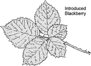
the creek. Two types of blackberry are profuse: the native California blackberry and the Himalayan blackberry.
One hardy, native, ground cover, man-root, with leaves similar to German ivy, produces curly tendrils and spiky little green balls. Soap plant, horsetail, five species of ferns, and myriad other natives flourish along
the creek. Two types of blackberry are profuse: the native California blackberry and the Himalayan blackberry.
In areas beyond the restoration, exotic trees, like Dutch elm, eucalyptus, and acacia, seem totally at home among the bay, oak, buckeye, alder, and redwood native to the canyon, as do the Monterey pines, introduced from another part of California.
The trail provides good access to the water. WPA park-improvement projects built concrete walls along the streambank. Fifty years ago, concrete was poured at one spot to stabilize and control the creek's natural flow. But, water sweeping around and under this unyielding, unabsorbent material has eroded a great gap, leaving a concrete "tongue" projecting above the creekbed.
Walls built from train track cross the creek regularly. It is said that they originally prevented people from driving up the creekbed! Dirt and debris have completely filled in behind these walls, and now they function as trash racks and check dams that slow the water flow.
Relatively few creatures live in the calm water. But, where there is a faster-flowing riffle the bottom is scoured cleaner, the water is more oxygenated, and the rough bottom provides microhabitats that support diverse plant and animal life.
You can gauge the stream's health by looking for algae and bacterial growth, indicating pollution and a lack of grazing insects. A sewer line runs underground alongside Sausal Creek. Its manholes are visible along the trail and its old pipes undoubtedly leak into the stream. Heavy rains also can affect water quality. The urban runoff -- laced with street grime, fertilizer, detergents, and motor oil -- flows down gutters and storm drains into the creeks.
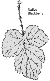
Continuing upstream you come to a dramatic view -- bay trees arch across the canyon, echoed by the arching Leimert Avenue bridge. Past the bridge, a spring flows out of a rock on the north bank, creating a mossy glade of ferns, blackberry, water parsley, and horsetail. A concrete flood control flume drains the hillside to the right.
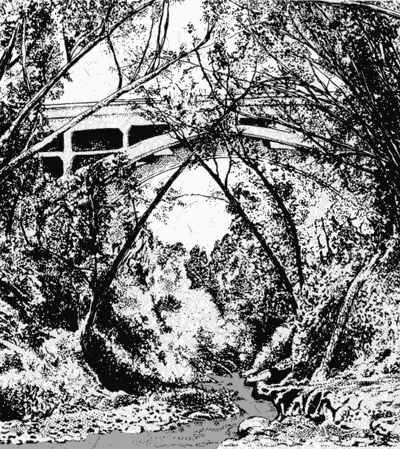 The creekbed now becomes the trail, so it may be difficult or impassable during rainy seasons. Follow the creek beyond where it runs through a tunnel built to protect it from the sliding hillside to the right. About 130 yards further, cross the creek on a weir Watching out for poison oak, take the trail that zigzags up the hill to the right.
At the top, walk left on the trail, an old road into Upper Dimond Canyon that was once a continuation of Bridgeview Drive. You will soon see a huge net across the canyon where the creek disappears under the Montclair Golf Course, built in the 1950s. A raw gully cuts into the hillside, the result of erosion. In 1982, the poorly engineered drainage system, diverting water from its natural course that led onto the driving range, "blew out" in a storm. You can see the broken pipe in the streambed below. From this vantage point, you can see clearly how the driving range and clubhouse were built directly over the creek. The Shepherd Canyon and Palo Seco branches of Sausal Creek meet in the eucalyptus grove at the eastern end of the parking lot.
Continue along the trail into a spectacular redwood canyon and the valley formed along the Hayward Fault. The jog to the right as you follow the Palo Seco branch indicates millennia of geologic displacement along this fault. Highway 13 runs through this valley. Although traffic sounds from the freeway and Park Boulevard are loud, you also can hear many birds. There is a sense of otherworldliness in this area, of stepping into the past.
Just before the trail/former road disappears into undergrowth, take the set of steps leading into the canyon. Near the bottom, a concrete pad once anchored a suspension bridge across the creek. Cross the creek on the low check dam. Take the path up to Monterey Boulevard, ending at the Dimond Canyon Hiking Trail sign like the one at El Centro.
Although this walk ends where the trail climbs above the creek, you can turn right on Monterey Boulevard, and take a pedestrian trail under the freeway. This puts you on Palos Colorados trail, which goes up hill through Joaquin Miller Park, and into the San Leandro Creek drainage. Both San Leandro and Sausal Creeks Drain into San Leandro Bay, demonstrating the ties between the watersheds we inhabit.
-- Shelby Hall
Chapter 9 Chapter 11 |
Top of PageTable of ContentsGlossary |