GUIDE TO EAST BAY CREEKS
Chapter Eleven
Damon Marsh Walk
This is an easy, if sometimes muddy, walk hidden in a somewhat desolate industrial area. Part of the trail is paved and suitable for strollers or wheelchairs, although it may take some assistance to get from the parking lot to the trail until the park is further developed.
Arroyo Viejo Creek drains the western Oakland Hills between Merritt College and Knowland Park. Three branches meet under I-580 and Golf Links Road and run across East Oakland, mostly through open, but private, land. You may see it as a concrete channel in the middle of Hegenberger Road, or a muddy ditch behind the Coliseum.
The creek enters the Bay at Damon Marsh, part of Martin Luther King, Jr. Regional Shoreline, which encircles San Leandro Bay. San Leandro Bay is an estuary, the meeting place of fresh and salt water. Before dredging and filling began in the mid-19th century, Sausal, Peralta, East, Arroyo Viejo, Lion, Elmhurst, and San Leandro creeks drained into the area creating fresh and salt water marshes, tidal sloughs and mudflats. These areas supported a staggering abundance of plant and animal life in a complex food web. Native American peoples had lived on its largesse for thousands of years.
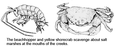
To get there, take the 66th Avenue exit from I-880 west to Oakport Street, and turn right to Curt Flood Field. Park here and walk out to the Damon Marsh Trail. If you turn right, the paved trail leads to East Creek Slough, where Peralta and East creeks drain into the Bay. A footbridge across the slough leads to part of the Shoreline yet to be developed; a derelict ship rusts offshore.
To explore marshland and get to the mouth of Arroyo Viejo Creek, turn left on the trail. Past the picnic tables the trail curves east, and you get a view of Damon Marsh. This small patch of pickleweed and Arrowhead Marsh, which you can see to your right sticking out into San Leandro Bay, are all that is left of once-extensive marshes. They ran from beyond the airport in the west, over the now industrial areas around Hegenberger and Edgewater roads, and continued inland past the Coliseum.
As you near the mouth of Arroyo Viejo Creek, also called Damon Slough, you begin to see salt marshes, recognizable by the thick cushion of succulent pickleweed growing on the mudflats. Pickleweed not only looks like tiny pickles but can be used in salads! Like all marsh plants, it absorbs a lot of salt. Pickleweed concentrates the salt in its tips, which turn red, die, and fall off, cleansing the plant of salt. In the summer, pickleweed may be host to a bright orange parasitic plant called dodder.
Another typical salt marsh plant is cord grass, found closer to the water. It is a tall, slender grass that grows in bunches. Growing in dense mats further inland is salt grass, smaller than cord grass, often mixed with pickleweed.
The marshes and mudflats are teeming with aquatic life — rewarding sites for exploration. They are connected by tidal sloughs like the small one that runs through Damon Marsh today. These waterways flood and drain the marshes twice a day. Like the mudflats, they are full of clams, worms, snails, mussels and crabs that pro-vide food for a great variety of shorebirds. Great and snowy egrets, cormorants, grebes, and the endangered clapper rail feed at the edge of the water.
Low tide is the best time to explore the mudflats. (Tide tables are available in newspapers, at bait shops, or from the Crab Cove Visitor Center in Alameda). Stick your finger in the mud and imagine the hundreds of tiny plants and worms that inhabit its richness. Turn over one of many rocks along the shore — remembering two simple rules: never move a rock bigger than your head, and put everything back exactly where you find it. Look for little arthropods called "beach hoppers" and small crabs. Gently turn a crab over to tell its sex: males have a triangular shape on their undersides, females a half circle. But watch out, they pinch!
A lot of debris of human life is deposited in this area, thought provoking and instructive to the contemporary "archaeologist." Before human garbage, the creeks washed plant and animal debris down to the mudflats where it became part of the "fertilizer" for the natural productivity of the marshes. Today's debris is recognizable — items we have all unthinkingly tossed away. Urban runoff entering the creeks through the city's storm drains is also deposited here, a major source of Bay pollution. The juxtaposition of garbage with wild life, highways and industry with wetlands, forcefully demonstrates the need for people to assume active responsibility toward their natural environment.
Where you reach the end of the paved path, you can continue walking along the edge of the marsh and through a brushy area to the mouth of the creek. Native coyote bush and hardy invaders, scotch broom and pampas grass, are establishing themselves on hummocks of land where loads of fill were dumped into the marshland.
The move to preserve San Leandro Bay began when the Port of Oakland filled a 200-acre marsh area between Arrowhead Marsh and Pardee Road in 1970. The move was highly criticized, leading to creation of the protected Regional Shoreline in 1976. The 72 acres of Damon and Arrowhead Marshes are all that remain of over 2,000 acres of marshland that surrounded San Leandro Bay in 1915. These few acres are precious!
-- Shelby Hall
Chapter 10 Chapter 12 |
Top of PageTable of ContentsGlossary |