Guide to San Francisco Bay Area Creeks
Alameda Creek
Flood Control Channel
Watershed
As recently as the 1950s Alameda Creek would flooded out of its main channel and into other distributary channels. These could
range from from Mount Eden Creek down to Mowry Slough. Most recent floods were into Crandall Creek and Sanjon de los Alisos. Now the flows of Alameda
Creek are held within the flood-control channel, and the rest of the watersheds now carry mostly local urban runoff.
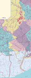
Watershed map, click to enlarge
|
|
 |
Alameda Creek, Fremont Region (235k) |
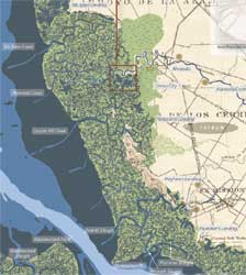
Fremont Area Historical Baylands Map |
|